


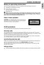
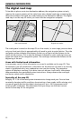
The digital road map
To be able to plan a route to a destination address, the navigation system not only
requires the current position of the vehicle but also a digital road map containing the
destination address itself and the roads leading to the destination address. This digital
road map is on the map CD which you insert into the navigation computer.
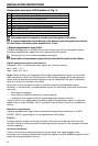
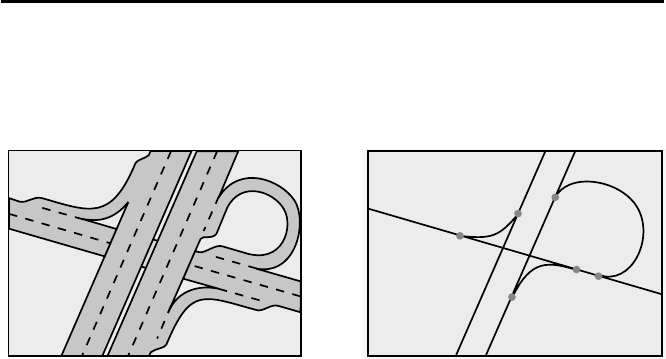
The road system is stored on the map CD as a line model, i.e. even large junctions have
only one focal point that is approached by all roads in point-to-point fashion. Thus the
navigation system indicates the distance to the turn-off point as the distance to the
centre of the junction. This is why the distances indicated on main road signs may not
agree with those of the navigation system. The road signs indicate the distance to the
beginning of the exit.
Areas with limited road information
In some areas, not all of the information on a road is available on the map CD. Thus,
for example, turn-off prohibitions, information on the direction of travel in a one-way
street or prohibited entry into a pedestrian zone may be missing. The navigation
system will display a warning if you drive into such an area. Local traffic laws always
take precedence over navigation system instructions. Always observe the road signs
and motor vehicle traffic regulations.
Topicality of the map CD
Roughly 10 - 15% of the road system characteristics change each year. Due to these
constantly changing traffic conditions (construction of new roads, traffic calming, etc.)
we cannot guarantee that the digital road map will be in 100 % agreement with
existing traffic conditions. We recommend that you always use the most current
version of the map CD for navigation.
GENERAL INFORMATION
12
Real road network Digital line model