


25
Chapter 1 Basic Operation
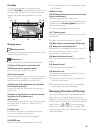
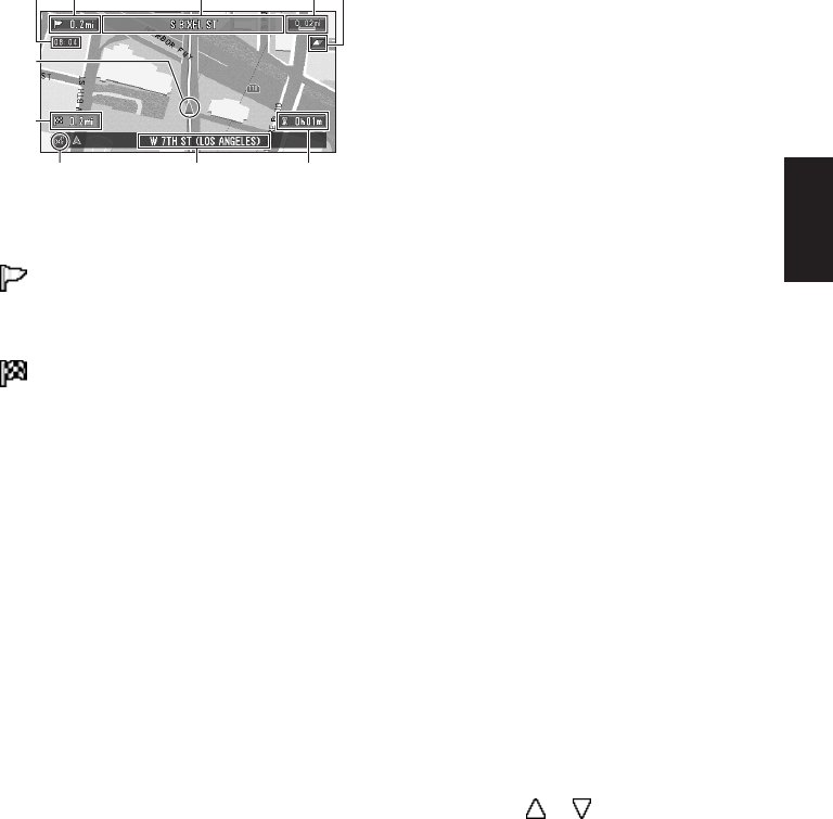
City Map
In certain metropolitan city areas, a more
detailed “City Map” is available at the 0.05 mi (50
m) map scale or lower (only those cities whose
detailed city maps are registered in the map
disc).
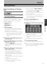
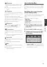
Display items
Guidance point*
The next guidance point (next turning point, etc.)
is shown by a yellow flag.
Destination*
The checkered flag indicates your destination.
(1) Name of the next street to be used*
(2) Distance to the guidance point*
Touch to access the next information.
(3) Current location
The current location of your vehicle. The tip of the
triangular mark indicates your heading and the
display moves automatically as you drive.
(4) Distance to the destination (or distance
to the next way point)*
If way points are set, the display changes with
each touch.
(5) Name of the street your vehicle is travel-
ing along (or City Name, etc.)
(6) Compass
The red arrow shows North. Each touch changes
the map’s display direction. (North is UP or
Heading Up.)
(7) Map scale
The scale of the map is indicated at distance.
Touch to change the map’s scale.
➲ Changing the map’s scale ➞ Page 25
(8) VOICE icon
Touch to change to voice recognition mode.
➲ The voice operation of the navigation system
➞ Chapter 5
(9) Current time
(10) Estimated time of arrival (or travel time
to your destination)*
The display changes with each touch.
The estimated time of arrival is automatically cal-
culated from the Average Speed set and the
actual average speed.
➲ How to set average speed ➞ Page 49
(11) Tracking mark
The tracking mark shows the route your vehicle
has traveled.
➲ Select the tracking setting ➞ Page 50
(12) Map of your surroundings (Side map)
(13) Distance to an intersection*
Displayed on the enlarged intersection map. The
green bar gets shorter as your vehicle
approaches an intersection.
(14) Next direction of travel*
When you approach an intersection, it appears
green.
(15) Area to Avoid*
➲ About detour area ➞ Page 43
(16) Direction line
The direction towards the location set in (4) is
indicated with a straight line.
❒ Information with the mark (*) appears only
when the route is set.
❒ Depending on the conditions and settings,
some items may not be displayed.
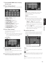
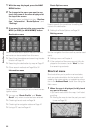
Changing the scale of the map
Touching the “Map scale” key displayed on the
upper right of the screen displays the scale
gauge and Direct scale key. Directly touching the
Direct scale key changes the map to the selected
scale. Touching or on the scale gauge
allows you to specify the scale in greater detail
within a range of 25 yards - 1000 miles (25 meters
- 2000 kilometers).
(2) (1) (7)
(5) (10)(8)
(3)
(4)
(9) (6)