


45
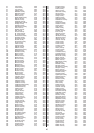
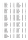
AR Saline County 34.6 -92.6
AR Scott County 34.9 -94.1
AR Searcy County 35.9 -92.7
AR Sebastian County 35.3 -94.4
AR Sevier County 34.0 -94.3
AR Sharp County 36.2 -91.5
AR Stone County 35.9 -92.2
AR Union County 33.2 -92.6
AR Van Buren County 35.6 -92.4
AR Washington County 36.1 -94.2
AR White County 35.3 -91.7
AR Woodruff County 35.2 -91.2
AR Yell County 35.0 -93.4
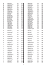
CA Alameda County 37.7 -122.1
CA Alpine County 38.6 -119.9
CA Amador County 38.4 -120.7
CA Butte County 39.6 -121.6
CA Calaveras County 38.2 -120.6
CA Colusa County 39.2 -122.2
CA Contra Costa County 37.9 -122.1
CA Del Norte County 41.7 -124.1
CA El Dorado County 38.8 -120.6
CA Fresno County 36.6 -119.9
CA Glenn County 39.6 -122.3
CA Humboldt County 40.7 -124.0
CA Imperial County 33.0 -115.5
CA Inyo County 36.7 -117.7
CA Kern County 35.3 -118.7
CA Kings County 36.2 -119.8
CA Lake County 39.0 -122.8
CA Lassen County 40.6 -120.7
CA Los Angeles County 34.1 -118.2
CA Madera County 37.0 -120.0
CA Marin County 38.0 -122.6
CA Mariposa County 37.6 -120.0
CA Mendocino County 39.4 -123.4
CA Merced County 37.2 -120.7
CA Modoc County 41.5 -120.8
CA Mono County 37.9 -119.0
CA Monterey County 36.5 -121.5
CA Napa County 38.4 -122.3
CA Nevada County 39.3 -120.8
CA Orange County 33.7 -117.9
CA Placer County 39.0 -120.9
CA Plumas County 40.0 -120.9
CA Riverside County 33.8 -116.8
CA Sacramento County 38.6 -121.4
CA San Benito County 36.7 -121.3
CA San Bernardino County 34.4 -117.0
CA San Diego County 32.9 -117.1
CA San Francisco County 37.8 -122.4
CA San Joaquin County 37.9 -121.3
CA San Luis Obispo County 35.4 -120.6
CA San Mateo County 37.5 -122.3
CA Santa Barbara County 34.6 -120.1
CA Santa Clara County 37.3 -121.9
CA Santa Cruz County 37.0 -122.0
CA Shasta County 40.7 -122.1
CA Sierra County 39.6 -120.5
CA Siskiyou County 41.6 -122.5
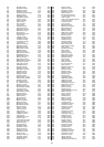
CA Solano County 38.2 -122.1
CA Sonoma County 38.4 -122.8
CA Stanislaus County 37.6 -121.0
CA Sutter County 39.1 -121.7
CA Tehama County 40.1 -122.1
CA Trinity County 40.7 -123.1
CA Tulare County 36.2 -119.2
CA Tuolumne County 38.0 -120.2
CA Ventura County 34.3 -119.0
CA Yolo County 38.6 -121.8
CA Yuba County 39.2 -121.4
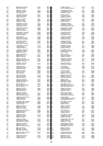
CO Adams County 39.9 -104.9
CO Alamosa County 37.5 -105.8
CO Arapahoe County 39.6 -104.8
CO Archuleta County 37.2 -107.1
CO Baca County 37.3 -102.5
CO Bent County 38.1 -103.1
CO Boulder County 40.1 -105.2
CO Chaffee County 38.7 -106.1
CO Cheyenne County 38.8 -102.5
CO Clear Creek County 39.7 -105.6
CO Conejos County 37.2 -106.1
CO Costilla County 37.3 -105.5
CO Crowley County 38.2 -103.8
CO Custer County 38.1 -105.4
CO Delta County 38.8 -107.9
CO Denver County 39.7 -105.0
CO Dolores County 37.8 -108.6
CO Douglas County 39.5 -104.9
CO Eagle County 39.6 -106.7
CO Elbert County 39.3 -104.3
CO El Paso County 38.9 -104.7
CO Fremont County 38.4 -105.3
CO Garfield County 39.5 -107.7
CO Gilpin County 39.8 -105.5
CO Grand County 40.1 -106.1
CO Gunnison County 38.6 -107.0
CO Hinsdale County 37.8 -107.3
CO Huerfano County 37.6 -105.0
CO Jackson County 40.6 -106.3
CO Jefferson County 39.7 -105.1
CO Kiowa County 38.4 -102.6
CO Kit Carson County 39.3 -102.5
CO Lake County 39.2 -106.3
CO La Plata County 37.3 -107.8
CO Larimer County 40.5 -105.2
CO Las Animas County 37.2 -104.4
CO Lincoln County 39.1 -103.6
CO Logan County 40.7 -103.1
CO Mesa County 39.1 -108.5
CO Mineral County 37.7 -106.9
CO Moffat County 40.6 -108.1
CO Montezuma County 37.4 -108.6
CO Montrose County 38.4 -108.2
CO Morgan County 40.3 -103.8
CO Otero County 38.0 -103.7
CO Ouray County 38.1 -107.8
CO Park County 39.2 -105.7
CO Phillips County 40.6 -102.4
CO Pitkin County 39.2 -106.9
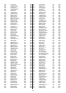
CO Prowers County 38.1 -102.4
CO Pueblo County 38.2 -104.6
CO Rio Blanco County 40.0 -108.3
CO Rio Grande County 37.6 -106.3
CO Routt County 40.5 -106.9
CO Saguache County 38.1 -106.2
CO San Juan County 37.8 -107.7
CO San Miguel County 38.0 -108.4
CO Sedgwick County 40.9 -102.3
CO Summit County 39.6 -106.1
CO Teller County 38.9 -105.2
CO Washington County 40.1 -103.1
CO Weld County 40.3 -104.7
CO Yuma County 40.0 -102.5
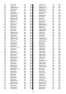
CT Fairfield County 41.2 -73.4
CT Hartford County 41.8 -72.7
CT Litchfield County 41.8 -73.2
CT Middlesex County 41.4 -72.5
CT New Haven County 41.4 -72.9
CT New London County 41.4 -72.1
CT Tolland County 41.9 -72.4
CT Windham County 41.8 -72.0
DE Kent County 39.1 -75.6
DE New Castle County 39.7 -75.6
DE Sussex County 38.7 -75.3
DC District of Columbia 38.9 -77.0
FL Alachua County 29.7 -82.4
FL Baker County 30.3 -82.2
FL Bay County 30.2 -85.6
FL Bradford County 29.9 -82.1
FL Brevard County 28.2 -80.7
FL Broward County 26.1 -80.2
FL Calhoun County 30.4 -85.2
FL Charlotte County 27.0 -82.1
FL Citrus County 28.9 -82.5
FL Clay County 30.0 -81.8
FL Collier County 26.2 -81.7
FL Columbia County 30.2 -82.6
FL DeSoto County 27.2 -81.9
FL Dixie County 29.6 -83.1
FL Duval County 30.3 -81.6
FL Escambia County 30.5 -87.3
FL Flagler County 29.5 -81.2
FL Franklin County 29.8 -84.8
FL Gadsden County 30.6 -84.6
FL Gilchrist County 29.7 -82.8
FL Glades County 26.9 -81.2
FL Gulf County 29.9 -85.3
FL Hamilton County 30.5 -82.9
FL Hardee County 27.5 -81.8
FL Hendry County 26.7 -81.2
FL Hernando County 28.5 -82.5
FL Highlands County 27.4 -81.4
FL Hillsborough County 28.0 -82.4
FL Holmes County 30.9 -85.8
FL Indian River County 27.7 -80.5
FL Jackson County 30.8 -85.2
FL Jefferson County 30.5 -83.9
FL Lafayette County 30.0 -83.2
FL Lake County 28.8 -81.7