Note:
After setting up, readings for weather forecasts should be disregarded for the next 12-24 hours. This will allow sufficient time for the Weather Station to collect air pressure
data at a constant altitude and therefore result in an more accurate forecast.
Common to weather forecasting, absolute accuracy cannot be guaranteed. The weather forecasting feature is estimated to have an accuracy level of about 75% due to the
varying areas the Weather Station has been designed for use in. In areas that experience sudden changes in weather (for example from sunny to rain), the Weather Station
will be more accurate compared to use in areas where the weather is stagnant most of the time (for example mostly sunny).
If the Weather Station is moved to another location significantly higher or lower than its initial standing point (for example from the ground floor to the upper floors of a house),
remove the batteries from both the Weather Station and transmitter and re-insert them after about 30 seconds. By doing this, the Weather Station will not mistake the new
location as being a possible change in air-pressure when really it is due to the slight change of altitude. Again, disregard weather forecasts for the next 12 to 24 hours as this
will allow time for operation at a constant altitude.
The weather tendency indicator
Working together with the weather icons are the weather tendency indicators (located above and below the weather icons). When the indicator points upwards, it means that
the air-pressure is increasing and the weather is expected to improve, but when indicator points downwards, the air-pressure is dropping and the weather is expected to
become worse.
Taking this into account, one can see how the weather has changed and is expected to change. For example, if the indicator is pointing downwards together with cloud and
sun icons, then the last noticeable change in the weather was when it was sunny (the sun icon only). Therefore, the next change in the weather will be the cloud with rain
icons since the indicator is pointing downwards.
Note:
Once the weather tendency indicator has registered a change in air pressure, it will remain permanently visualized on the LCD.
Storm warning indicator:
The downward tendency indicator will flash if the air pressure has dropped by 4 hPa or more in the last 6 hours.
Relative air pressure inHg
Underneath the weather icons is the air pressure reading which is recorded constantly in inHg and the Weather Station displays this reading as the relative air pressure.
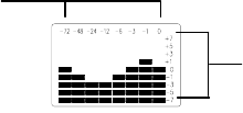
Air pressure history (electronic barometer with barometric pressure and trend)
(Each bar represents 1 hPa (millibar); 1hPa = 0.03 inHg (inches of mercury))
The bar chart indicates the air pressure trend over the last 72 hours in 8 steps, 0, -1, -3, -6, -12, -24, -48 and -72 hours. The bar is plotted at each of the right (0, ±1, ±3, ±5,
and ±7) compares the result. The “0“ in the middle of this scale is equal to the current pressure and each change (±1, ±3, ±5, and ±7) is how high or low in “hPa“ the past
pressure was compared to the current.
If the bars are rising it ,it means that the weather is getting better due to the increase of air pressure. If the bars go down, it means the air pressure has dropped and the
weather is expected to get worse from the present time “0“.
Note:
For accurate barometric pressure trends, the Weather Station should operate at the same altitude for example, it should not be moved from the ground to the second floor of
the house. Should the unit be moved to a new location, reset both the transmitter and Weather Station as this will prevent the slight change in lication registrering as a
possible change in air pressure.
After the resetting or setting up, weather readings should be discarded for the next 12 to 24 hours as this will allow sufficient time for the Weather Station to operate at a
constant altitude and thus enabling a more accurate reading.
Outdoor temperature reading
The outdoor temperature is displayed underneath the weather icon section. The Weather Station will automatically start scanning for the transmitter’s 433MHz signal after the
batteries are inserted and once received, the outdoor temperature will appear on the LCD.
Minimum and maximum outdoor temperature readings
Underneath the current outdoor temperature, are the outdoor minimum and maximum temperature recordings. When a new temperature low or high is reached, it will be
updated and recorded into the Weather Station memory.
Automatic minimum and maximum indoor andoutdoor temperature resetting
The Weather Station is programmed to reset the indoor minimum and maximum temperature recordings once a day. The maximum temperatures are reset at 8:00am and the
minimum temperatures at 8:00pm.
Checking for 433MHz reception
The Weather Station will automatically start scanning for the 433MHz signal after the batteries are inserted. If the outdoor temperature is not displayed after about 30 seconds,
then check the following list before resetting the units (see Resetting below):
1. The distance of the receiver or transmitter should be at least 1.5 to 2 meters away from any interfering sources such as computer monitors or TV sets.
2. Avoid placing the receiver onto or in the immediate proximity of metal window frames.
3. Using other electrical products such as headphones or speakers operating on the same signal frequency (433MHz) may prevent correct signal transmission and
reception.
4. Neighbours using electrical devices operating on the 433MHz signal frequency can also cause interference.
Air pressure over
the last 72 hours
Air pressure scale
